Ananto
Ananto is a District of Kalistan, seperated from the rest of the country by the Ananto Strait. It is an island, technically a part of Keris. It is home to the capital and largest city of Kalistan, Kaliburg, and has the largest population of any District.
Brief History[]
Ananto was settled at the same time as Mainland Kalistan but was viewed as a Separate colony. Eventually an empire rose on Ananto which conquered not only Mainland Kalistan, which it promptly annexed, but also parts of Lodamun, Baltusia and Gaduridos. The Empire shrunk to Kalistan's current size before the Historical era began, and yet the seat of power remained in the District.
Now, the Island is seen as the center of culture, influence and finance in the Republic. Its climate is substantially different than the rest of the Republic, being largely maritime, as are its crops therefore also allow the Republic some variety.
There have been a number of independence movements demanding Anantonese Independence in the past, though these political movements have not borne fruit given Ananto's centrality to the identity of the Republic.
Geography[]
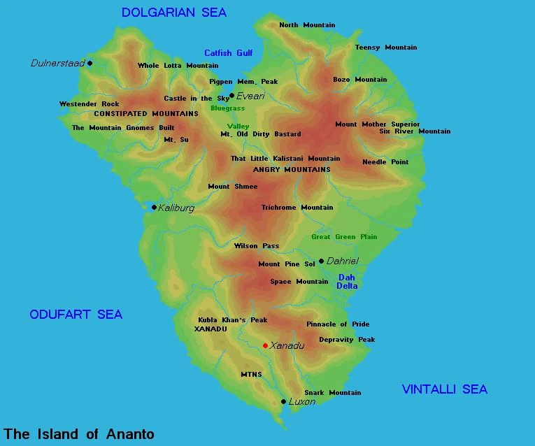
Map of Ananto
Ananto is an island located 500 miles offshore, midway between Seleya, Dovani, and Keris. It is kept cool on its western coast by the artic North Seleyan drift, and warmed on the east by the tropical Dovani Stream. Down the center of the Y-shaped island are the Angry Mountains, a chain of volcanic peaks, and the less volcanic Constilated Mountains. The tallest mountain on Ananto is also the most volcanic, the infamous Mount Mother Superior. Along the western shore, towards the south, are the smaller Xanadu Mountains. The western side of the island is cool and fertile, with cold, rainy winters. The eastern side is home to a large, fertile plain. The northern side is a very rocky landscape, suitable mainly for grazing.
The largest city of Ananto is Kaliburg-Port Davon, which is also the District and national capital. It is located about halfway up the western shore, where the Zappa River empties into Davon Bay. The second largest city is Luxon, on Luxon Bay at the island's southern tip. Other large cities are Dahriel, in the east which is the center of large scale marijuana growth operations, Dulnerstaad, in the northwest, which is home to the Dulnerstaad Naval Base, Eveari, in the north, and Xanadu, in the Alph Valley between Kaliburg and Luxon.
Ananto also hosts the Bozo River Combined Arms Training Center, at the small town of Bozo River on the north east tip of the Island. This multi-purpose facility is a favorite of Kalistani Regulars for combined arms training.
| Kalistan articles | ||
| History | Jorge I of Ananto | Ananto War | Kalistan/Gaduridos War | Crisis of 2342 | Reynoldia Crisis | |
| Geography | Ananto | Neveras | Suldanor | Odufaray | Vrassa | Maps
| |
| Politics | Government | National Assembly | Political parties | President | Ethical Socialism | Introduction | Constitutional Court | |
| Demographics | Ethnic Groups: Kalistani | Mu-Tze | Anantonese Religion: Society of Brethren | Akalism | Bishopal Church | |
| Culture | Languages | Reggae | Retro-Futurism | Floob | House Ananto | |
| Economy | Big Three | Corporations | Divestment | Ruble | Treacle | |
| Nat. Ind. | ODEN | KALNAPECO | KALNAFERCO | KALMILINCO | KALNATEXCO | KALNAMOCO | Republican National Bank | |