Republic of Valruzia is the largest country on Terra (represented in the World Congress) by surface area with 1.93 million square kilometers and one of the most populous country (most populous in Seleya). Thanks to its relatively high level of urbanization and big numbers of city agglomerations it has a moderately sparse but at the same time extensive network of transport infrastructure.
Valruzia has approximately 1.1 million kilometers of roads. 53 thousand kilometers of those create a network of high-speed highways known in Valruzia as Autostrada, ann expressways known in Valruzia as Droga Eksrpresowa. The remaining part creates a system of Voivodeship, County and Municipality roads (val. Drogi Wojewódzkie, Powiatowe, Gminne). The railroad network of Valruzia has 39 thousand kilometers in length. The biggest airports in the country are: Nowogard Ignanski Airport and Brzansk - Olimpia Airport. The most important waterways are Libard and Luzyca river.
Although infrastructure in Valruzia remains on the relatively high level of development, the national government still has to face a big disparity in the transport infrastructure depending on the region, and invest heavily in the infrastructure sector with aim of improving the condition of roads and railroad in most rural areas, especially in Gryfit and Chynberg Voivodeships.
Roads and Automotive Transport[]
| Valruzian Transport Network Sieć Komunikacyjna w Walruzji | |
|---|---|
| Total Lenght: | |
| Roads | 1.100.000 km |
| Rail | 23.000 km |
|
| |
| Highway (Autostrada) |
53.500 km |
| Expressway (Droga Ekspresowa) |
190.000 km |
| Voivodeship Roads (Droga Wojewódzka) |
250.000 km |
| County Roads (Droga Powiatowa) |
290.000 km |
| Municipality Roads (Droga Gminna) |
316.500 km |
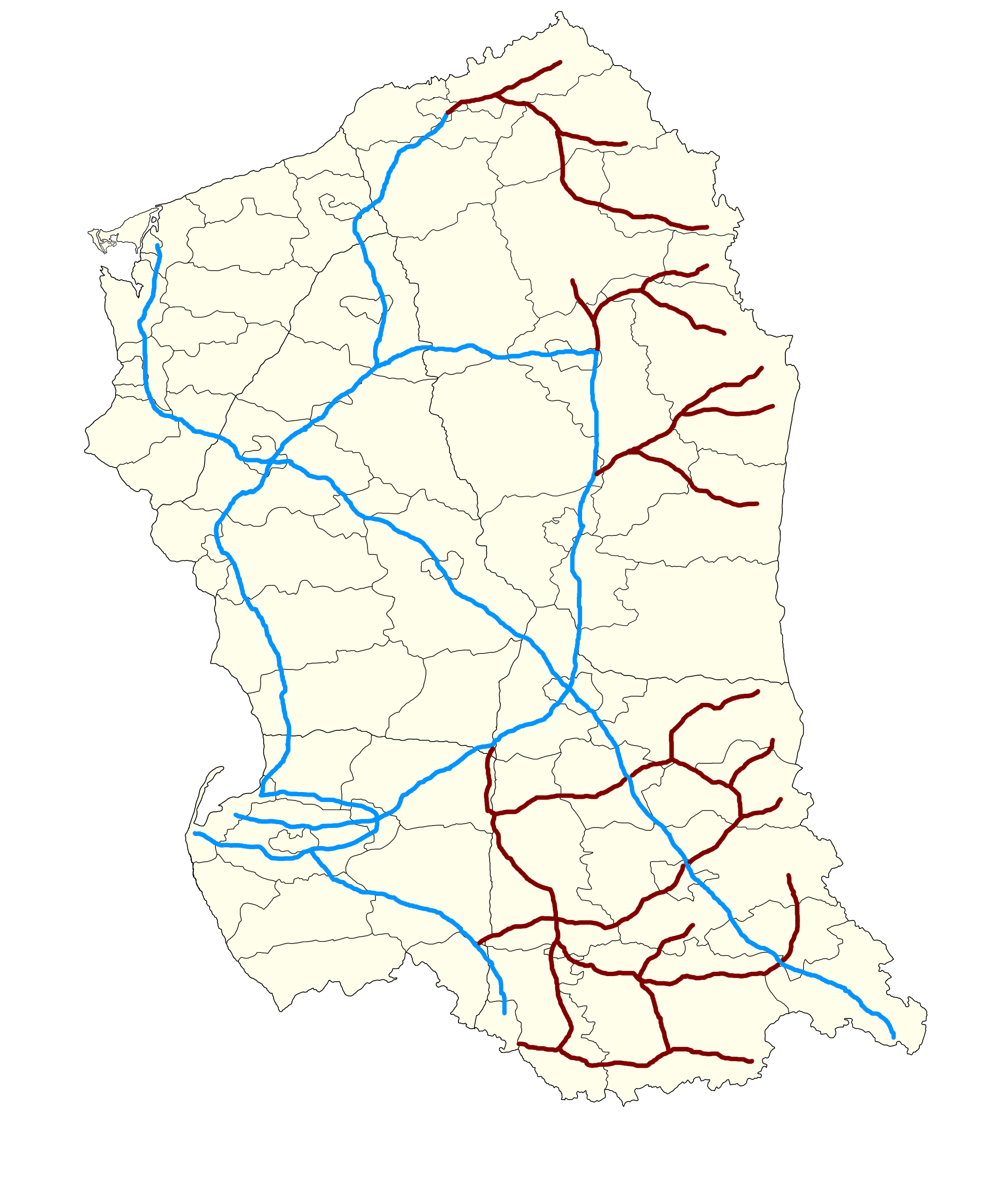
 Map of the most important express- and highways in Valruzia | |


Valruza, thanks to its location, serves as an important transit route from the north of the Seleyan continent to its southern parts. The country is home to many important communication routes known colloquially as Transseleyan Routes (Szlaki Transselejskie). The national government manages the roads in the country through a specialized governmental agency Supreme Inspectorate of Road Infrastructure (Naczelny Inspektorat Infrastructure Drogowej, NIID).Despite the government's efforts to transfer much of the cargo traffic from the he roads to trains, still, majority of transport is done by roads.
Roads[]
As said above, Valruzia has approximately 1.1 million kilometers of roads. The national government implemented a simple road classes category:
 The Autostrada is the highest level of the road network in Valruzia. 53.500 kilometers of Autostradas make up the National Highway Network of Valruzia (Nardowoa Sieć Autostradowa). The general speed limit on Valruzian highways is 140 kilometers per hour. In 4258, the NIID, on specially designated parts of highways, resigned from the blanket speed limits. Currently, 3.200 kilometers of Autostradas have no blanket speed limit. However, according to the NIID 140 km/h is still the advisory limit. The name of a particular highway consists of the letter A ( a shortcut from Autostrada) and a designated number. They have their own red-colored signs with the name of each highway on them. To be declared an Autostrada road has to fulfill several conditions, the most important is the absence of intersection (on the same level) with other roads, railways or pavements.
- Droga Ekspresowa (Expressway) is the second highest level of the road network in Valruzia. With 190.000 thousand kilometers of roads it is one of the most extensive expressways in Terra. The difference between Expressway and the Autostrada is that Expressways have intersections with other roads but not with railways and tramways. The general speed limit on the Expressway in Valruzia is 120 kilometers per hour. However if the expressway goes trough a built-up area or if the conditions of road surface diverges from the staturoty norms, the NIID can lower the speed limit to respectively 100 km/h, 80 km/h or 60km/h. Each express way has its unique name which consits of the letter S (shortcut of szybko - fast) and a designated number. They have their own blue-coloured signs with the name of each expressway on them.
- Droga Wojewódzka, DW (Voivodeship Road) is the higest level of roads on the voivodeship level. The main authority over the Voivodeship Roads lies within the Sejmik of the Voivodeship (Sejmik Voivodeship). It shares the jurisdiction over the DW with the NIID. The speed limit may vary in each voivodeship, but in general the average speed limit is 80 kilometers per hour. Each DW has its marking, it is isosceles trapezoid with letters DW in the upper part of the sign and a designated number on the bottom with dashes on each side of the number. Currently there is 250.000 kilometers of Voivodeship Roads.
- Droga Powiatowa, DP (County Road) is the network of roads within a particular county (powiat) and is usually maintaned by the County's authorities. Each country is responsible for its own network, however, a county can pass the jurisdiction to the NIID. There are 290.000 kilometers of Country Roads. The speed limit on country roads may vary in each county but is mostly dependant on surface and weather condition, but may not exceed 90 kilometers per hour. Each DP has its marking, it is rhombus with letters DP in the upper and bottom part of the sign and a designated number ion the middle with dashes on each side of the number.
- Droga Gminna, DG (Municipality Road) is a level of roads at the municipality level. The jurisdiction over this class of roads lies within the municipality authorities. Authorities of each municipality is responsible for maintanence of road within the municipality. Each DG has its marking, it is a yellow rectangle with black edges. Municipality roads have a specific numbers which consist of three digits.
Railway[]
| Valruzian Railway Network Sieć Kolejowa w Walruzji | |
|---|---|
| Total Lenght: | |
| Passenger and Cargo | 39.000 km |
| Cargo | 17.000 km |
|
| |
| Electrified | 17.500 km |
| Not Electrified | 21.500 km |
 Map of the railway network in Valruzia Blue represents tracks used by both passenger and cargo trains. Maroon represents tracks used only by caro trains. | |
Valruzia featres 39 thousand kilometers of railways, used for both passenger and cargo transportation. Accordin to the Ministry of Infrastructure and Transport 45% (17.5 thousand kilometers) of railway network in Valruzia is electrified.
The WKP Valruzian State Railway (WKP - Walruzyjskie Koleje Państwowe)is the major railway service and infrastructure operator. Although WKN is a joint stock company, and on legal terms it is treated as private company, the government of Valruzia, is the owner of all of the shares, so WKP can be called as state-owned company. Established in 4247, it is the largest operator of railway infrastructure and service provider in the region. It is de iure the manager of all the tracks in the country and can charge other operators for using railroads in Valruzia.
The WKP Valruzian State Railways accoridng to the staturory laws should be self-sufficent entity but as many of different business entites is has teright to file for subsidies from the National Economic Fund. The company is one of the smallest contributors of the fund and recives around 120 million pesos annually, which is used only for investments. The Ministry of Infrastructrue and Transport also invests in the WKN with 3.5 billion pesos reserved for investments and operational expenses of the WKN.
The WKP Valruzian State Railways provides short- and long-distance routes for its passengers. The operator upkeeps a wide range of inter-city connections as well as long international routes which are maintaned in cooperation with foreign state-owned or private railway operators.
The WKP provide services with its fleet of electric multiple unit and diesel-electric multiple units for passenger routes and diesel multuple units for cargo routes. The averge speed of passenger trains enroute is 160 kilometers per hour. WKP has 35 high speed multiple units with maximum speed exceeding 230 kilometers per hour.
One of the biggest issues of the railway in Valruzia is its relatively low density and (resulting from the low density) innability to meet 100% of customer demand. Currently there is a comprehensive public debate whether additional public funds should be transfered for constucting more dense railway. Proponents say that this would allow for less congested higways and cities and would create numerous jobs. Opossers say that theere isanegative trend for inter-city railway transport and that people preffer to go by car or by plane which is simply faster.
Air Transport[]
| Valruzian Airports Porty Lotnicze w Walruzji | |
|---|---|
 Airports in Valruzia |
Due to its large area, Valruzia has witnessed an increase in domestic passenger and cargo air transport. In recent years airlines providing flights on domestic routes began to be more competitive and is growing steadily. In 4291, 19% of distance travelled was by plane. On the other hand international air transport is heavily soldified within Valruzian market and due to its location Valruzia serves as a hub formany airlines in their intercoontinental, ultra long-haul routes.
Airlines[]
Valruzia's largest airline, and at the sametime its flag-carrier, is the LOT Valruzian Airlines, which was established in 4247 with Establishment of the State Owned Airways WLL LOT Act. Despite its legal status and functioning as a private business entity, all of LOT's shares are owned by the government of Valruzia. LOT started its own regional - Homeconnect, and international airlines - Interconnect, as well as designated cargo airline - LOT Cargo. And all together those function under the name LOT Group.
Valruzia is also home to a numerous regional and international airlines such as, HelloAir, Super7 or Valair.
Airports[]
Nowogard Ignanski Airport is the largest airport in Valruzia, one of Seleya's major transportation hubs. Other important airports in Valruzia are: Brzansk - Olimpia Airport, Hel International Airport and Gryfitow - Topolin Airport. Valruzia features several others airport with scheduled passenger or cargo traffic, serving mainly domestic routes or routes within the north of Seleya.
| Republic of Valruzia | |
|---|---|
| Politics | President • Prime Minister • Council of Ministers • Sejm • Marshall of Sejm |
| Law and Order | Valruzian Police • General Prosecutor • Valruzian Coastal Guard • Customs Office • Border Patrol |
| Administrative divisions | Chynberg Voivodeship • Gryfit Voivodeship • Kampania Voivodeship • Ruzian Voivodeship • Valusian Voivodeship |
| Cities | Nowogard • Brzansk • Hel • Gryfitow • Szary Kamien • Jeziorne Sady • Bawierzow • Garncagra • Szymonice • Baltunowice • Sztolniaty • Dabik • Pastarnia • Kninsk • Trebegowice • Uniatow |
| Economy | Corporations in Valruzia • Transport in Valruzia • National Institute of Social Services • Walatom • Enerwal • WKN Volantis |
| Military | National Forces of Defense of Valruzia |